Hong Kong’s metropolis is notorious for its complex, multi-level road systems, with flyovers, tunnels and complicated junctions. While such systems enable more traffic to pass through major cities, current GPS devices have problems identifying which road level a vehicle is on, leading to safety issues and frustration for drivers.
Professor Anthony Yeh Gar-on said: “Picture the scene, you are navigating in your car using a GPS, when instead of taking the road directly ahead as instructed, you erroneously veer into the left-hand lane which is the on-ramp of a flyover. Since the flyover is above the road which you are meant to be on, the GPS does not realise your mistake and continues to give you instructions as though you were on the road beneath. Not only does such a situation lead to extra stress for drivers, but it can also cause accidents.”
The GPS was developed in the 1970s and came into common usage in the 1990s, but failure to recognise road levels has been a persistent problem that has gone unresolved over the decades.
In multi-level road networks, the GPS flits between flyover and ground level as it cannot figure out where it is. “The horizontal error of GPS is 10 to 30 metres,” said Professor Yeh, “so it cannot always recognise which lane you are driving in. The vertical error is 15 metres, whereas flyover height is usually 9 metres. Furthermore, existing vehicle positioning systems use consumer-grade GPS and the transport geographic information system (GIS-T) database is largely two-dimensional only.”

![]() Our device enables you to trust your navigation system again – it gives you back your confidence in it. Safety is all about confidence.
Our device enables you to trust your navigation system again – it gives you back your confidence in it. Safety is all about confidence. ![]()
Professor Anthony Yeh Gar-on
Angle Difference Method
To solve the problem, Professor Yeh and Dr Zhong Teng, both from the Department of Urban Planning and Design, HKUrbanLab, GIS Research Centre and Institute of Transport Studies, developed the Angle Difference Method (ADM).
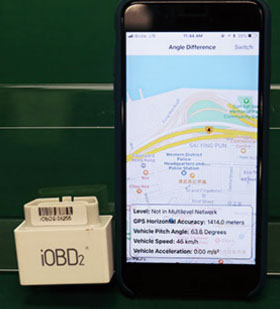
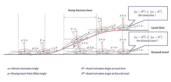
Dr Zhong said: “Our method compares the vehicle pitch angle with the inclination angle of different road levels calculated from road elevations which we propose will be stored in future in GIS-T databases. The method uses an onboard diagnostic (OBD) device, which measures the real-time velocity of the vehicle, and a smartphone whose motion sensors enable the device to compare the angle of the road with the angle of the car. In short, it works out if a car is entering the ramp of a flyover.”
To implement the Angle Difference Method, the vehicle inclination angle needs to be measured accurately, which existing in-vehicle inclinometers can do but they are both large and expensive. By comparison, the portable OBD is inexpensive and performs automatic calibration to remove the misalignment pitch offset angle in both stationary and moving modes.
Professor Yeh said: “Many modern vehicles already have an OBD, and with the advent of automatic cars all vehicles will have it. Nowadays, everybody has a smartphone – which contains, among other motion sensors, a gyroscope. The phone can be placed anywhere within the vehicle and will work with the plugged-in or installed OBD.”
“When a vehicle approaches what we term the Ramp Decision Zone,” said Dr Zhong, “the device compares the angle of road and vehicle and informs the driver instantly, and with 100 per cent accuracy, if he or she has entered a flyover.” This instant information reduces the chance of accidents or stress caused to driver trying to follow instructions from a GPS that thinks a vehicle is in a different road level to where it is actually located.
“When that happens people start to not trust the GPS device,” said Professor Yeh. “Our device enables you to trust your navigation system again – it gives you back your confidence in it. Safety is all about confidence.”
Professor Yeh and Dr Zhong have received both a US patent and an International PCT [Patent Cooperation Treaty] patent and they are currently talking to global GIS and vehicle navigation operators, regarding getting the relevant advice on flyover inclinations. These operators include major Chinese companies, with whom the team is discussing potential applications for the system, particularly in major cities with complex road systems.
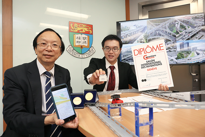
The invention won the gold medal at the Geneva International Exhibition of Inventions in April, 2018. It has also generated several academic papers published in top international academic journals including IEEE Transactions on Intelligent Transportation Systems.
“Navigation has always been one of my key research areas,” said Professor Yeh. “I have been involved in navigation research for some 20 years.” His work has included the international award-winning HKU Virtual Campus (Internet and Intranet GIS) in 1997, and a real-time traffic multimedia internet geographic information system in 1998.
The navigation system uses an ordinary smartphone which is connected to an onboard diagnostic device by Bluetooth.


The Angle Difference Method for determining which road level a vehicle has entered.
A new angle on navigation
The Urban Planning and Geographic Information Systems (GIS) team has found a solution to the blind spots in city roads that have eluded global positioning systems (GPS) for decades.

Professor Anthony Yeh Gar-on (left) and Dr Zhong Teng (right) won the gold medal at the Geneva International Exhibition of Inventions.
Home
November 2018
Volume 20
No. 1

